Marlborough District Council’s latest hydrodynamic models indicate a reduced risk from predicted sea level rise and coastal flooding in the Lower Wairau Plain near Blenheim.
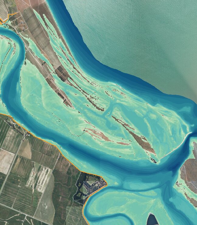
The Sea Level Rise Modelling and Lower Wairau Hydrodynamic Assessment, created by Earth Sciences NZ (formerly NIWA) for the Council, marks a significant step forward in Marlborough’s climate change adaptation efforts. Moving beyond previous static, or ‘bathtub’ models, the new modelling simulates water interactions with river channels, lagoons, stop banks and coastal barriers, providing a more accurate understanding of potential flooding, and supporting better risk management and planning.
Mayor Nadine Taylor welcomed the findings.
“The updated modelling is testament to Marlborough’s proactive approach to climate resilience,” she said.
“By building a stronger evidence base, we are equipping our community and decision-makers with the tools they need to adapt to changing coastal risks. The fact that we are seeing a reduced area of potential inundation gives us greater confidence as we plan for the future.”
The assessment, reported to today’s Environment and Planning Committee, shows that while the central and southern Wairau Plain remain vulnerable to even minor sea level rises, the potential flooding is less widespread than previously believed.
The study also identifies where overtopping of flood protection features might occur and notes a significant increase in risk of 1.8 to 1.9 metres of sea level rise. Importantly, the modelling confirms that coastal storms can elevate river levels, emphasising the need for coordinated river and coastal management, the Mayor said.
Council will use the improved information to inform policy, spatial planning, consenting and infrastructure investment, in line with national guidance and adaptive planning approaches.
This work is part of the Council’s Climate Change and Adaptation Action Plan, initially adopted in 2020 and recently updated to steer Marlborough’s climate initiatives through to 2028.
Council and Earth Sciences NZ are also examining the potential impacts of predicted sea-level rise on groundwater levels in the Lower Wairau Plain. Groundwater levels are higher on the lower plain, and Council manages a drainage network to keep the levels low and support land productivity. The results of this investigation are also expected this year.
For background information on Council’s Climate Change and Adaptation Action Plan, visit: www.marlborough.govt.nz/environment/climate-change.