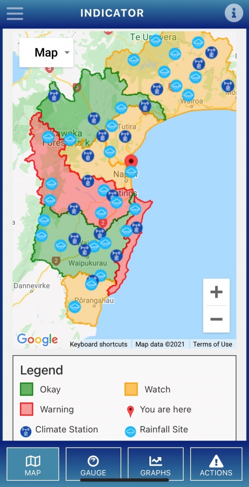
Hawke’s Bay Regional Council has launched an easy-to-use drought indicator web app for the region’s rural community.
The Regional Council designed the tool – the first of its kind in New Zealand – to build drought resilience in the community with funding from Ministry for Primary Industries and in partnership with the Hawke’s Bay Rural Advisory Group.
Group Manager of Integrated Catchment Management, Iain Maxwell says the app is a great way for farmers to get a pulse check on the key climate conditions on their farm and wider area and support planning for dry conditions and drought.
“Last year’s severe drought did catch out some in our rural community and showed us that more tools were required for our farmers to prepare and plan for drought. That is why we have developed this tool,” Mr Maxwell said.
The tool shows a ‘traffic light warning system’ for drought based on live rainfall, soil temperature, soil moisture, and evapotranspiration data from the council’s 50 climate stations around the region.
“It is intended to take the hassle out of accessing regional climate data for our farmers, and for them to be able to go to one place and get a live view of climate conditions,” he said.
Hawke’s Bay Rural Advisory Group chair, Lochie MacGillivray says the drought indicator was a fantastic tool that would support farmers to make decisions early and plan for drought.
The launch of the tool is timely as the region is experiencing concerning dry conditions, particularly in Coastal Hawke’s Bay as well as areas to the west of Hastings, Mr MacGillivray said.
The drought indicator shows Crownthorpe has the lowest soil moisture data recorded for the last 18 years, and will reach a stress point of limited pasture growth in 16 days if there is no rain.
“For farmers in this area, we would be recommending that they put together a feed budget and a plan for drought, and access the support of primary sector organisations if required.”
“We hope that this tool will be well used by the rural community, give them a forward- looking view of the dry conditions on farm, and help them to make those tough decisions early,” he said.
To access the tool, go to hbrc.govt.nz and search #droughtapp


